

Highlights
This is the loop that shows a visitor Oregon in a single day, and the one Portland riders come back to every summer. It starts on the first planned scenic highway in the United States, the Historic Columbia River Highway, which climbs from the Sandy River to Crown Point and then drops through a string of waterfalls to the floor of the Columbia River Gorge. The interstate carries you up the gorge to Hood River, where OR 35 turns south through apple and pear orchards towards the north face of Mount Hood and climbs to Bennett Pass at about 4,650 feet. US 26 brings you down through the forest to Sandy and back into the city, with the option of riding up to Timberline Lodge on the mountain's south slope.
It is about 163 miles with some 9,000 feet of climbing, all paved, and none of it technically hard: the corners on the old highway are tight but slow, and the mountain roads are wide, sweeping and well kept. What makes it a full day is the distance, the slow crawl past the waterfalls on a summer weekend, and about 29 miles of windy interstate in the middle. Any bike that is comfortable at highway speed will do. Ride it between June and September, when the passes are clear of snow, and start early: the old highway is at its best before the crowds arrive.
Longest stretch without a gas station: about 50 miles, between mile 16 and mile 66.
The ride, stop by stop
- 1mile 0
Start
Pioneer Courthouse Square

Photo: Steve Morgan, CC BY-SA 3.0 A brick-paved square of steps and terraces in the middle of downtown, known locally as Portland's living room, with the 1870s Pioneer Courthouse across Sixth Avenue. It is the easiest place in the city to name as a meeting point. From here the Morrison Bridge takes you over the Willamette and straight onto I-84 eastbound.
Tip: Fill up before the gorge: the last station on the route is near Troutdale, about 16 miles out, and the next is in Hood River, 50 miles further on.
The roadmiles 0–17
Out of Portland
Morrison BridgeI 84Interstate freewayAbout 17 miles of I-84, the Banfield Freeway, east from the Morrison Bridge. Weekday rush hours are heavy; on a weekend morning it is quick. Leave at the Lewis and Clark State Recreation Site exit by Troutdale, where the Historic Columbia River Highway begins. Fill up in Troutdale: there is no more fuel on the route for 50 miles.
The roadmiles 17–40
The Historic Columbia River Highway
US 30 HistoricNarrow two-lane road, tight curvesTwenty-two miles of the old road, built between 1913 and 1922. It follows the Sandy River upstream past Dabney State Recreation Area, then climbs about 800 feet through Springdale and Corbett, with farmland and the river in view, to the Portland Women's Forum viewpoint and Crown Point. The descent from Vista House drops in a series of looping hairpins at up to about 6% to Latourell Falls, then the road runs along the foot of the cliffs past Bridal Veil, Wahkeena, Multnomah and Horsetail Falls. Lanes are narrow, the stone guard walls sit right at the edge and speed limits are low. On summer weekends expect queues at every falls, walkers crossing between car parks and cyclists in both directions. The highway rejoins I-84 at Ainsworth State Park.
- 2mile 26.9
Viewpoint
Vista House at Crown Point
Allow 30 min

Photo: Chris[tmas K] from Portland, USA, CC BY-SA 2.0 A domed stone rest house, built between 1916 and 1918, on a basalt headland about 730 feet above the Columbia. The old highway circles it, so you ride right round the building, and from its terrace the gorge opens out east for miles. Stop a minute earlier at the Portland Women's Forum viewpoint, just over a mile before, for the classic view of Vista House on its cliff.
Tip: The car park is small and busy by mid-morning in summer, and the point is often very windy: park facing into the wind with the bike in gear.
- 3mile 35.2
Sight
Multnomah Falls
Allow 45 min
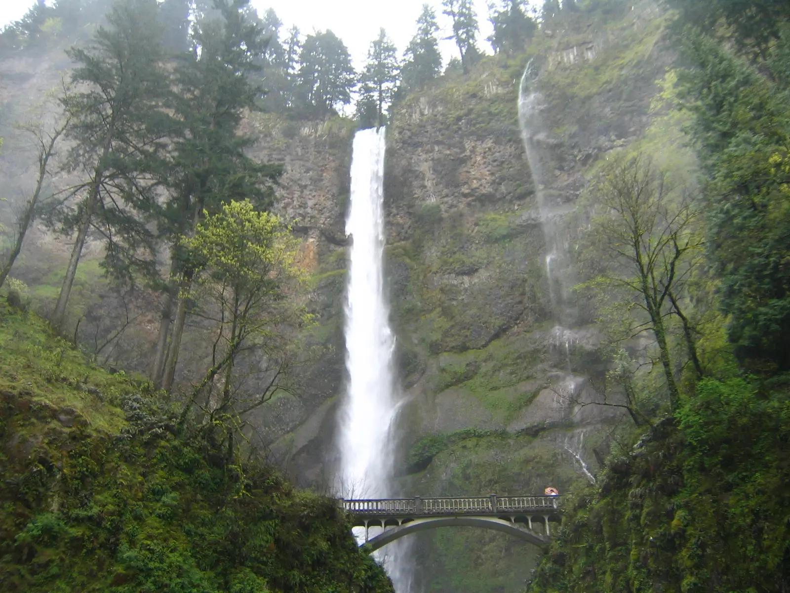
Photo: Unknown author, Public domain The tallest waterfall in Oregon drops about 620 feet in two tiers, with the stone Benson Bridge crossing between them. It stands right beside the old highway, next to Multnomah Falls Lodge, built in 1925. The view of both tiers from the plaza takes five minutes; the paved path up to the bridge takes a few more.
Tip: In recent summers the big Multnomah Falls car park off I-84 has needed a timed-use permit booked on Recreation.gov, while the historic highway has not, but roadside parking on the highway is very limited. Check Recreation.gov before a summer ride.
The roadmiles 40–69
Up the gorge on I-84
I 84Interstate freewayTwenty-nine miles east along the river, with basalt cliffs on both sides, past Cascade Locks and the Bridge of the Gods to Hood River. The road is easy, but the gorge funnels a strong west wind through most summer afternoons: gusts hit hardest at gaps in the cliffs and when you pass trucks. Keep a loose grip and give big vehicles room.
- 4mile 67.9
Food
Hood River
Allow 1 hour with lunch
A small river town on a slope above the Columbia, famous for windsurfing and kiteboarding, which thrive on the same wind that buffets you on the interstate. Downtown is a few blocks up the hill from I-84, with simple places to eat and a long view across the water to Washington. It sits almost exactly halfway round the loop and is the natural lunch stop.
Tip: Fill up here. Past the station a few miles up OR 35 there is nothing for 37 miles, all of it climbing, until Government Camp.
The roadmiles 69–107
OR 35 and the Hood River Valley
OR 35Two-lane highway, long climbOR 35 leaves the interstate east of Hood River and rolls south through orchards, with Mount Hood growing ahead. Beyond the upper valley the farms give way to forest and the road follows the East Fork Hood River upstream, climbing steadily at up to about 6% to Bennett Pass at about 4,650 feet, 32 miles from the interstate. The corners are fast and sweeping and the surface is generally good. Beyond the pass the road crosses the White River's wide stony channel and climbs again to Barlow Pass at about 4,150 feet before meeting US 26.
- 5mile 70
ViewpointDetour
Panorama Point
Allow 20 minAbout 1½ miles each way
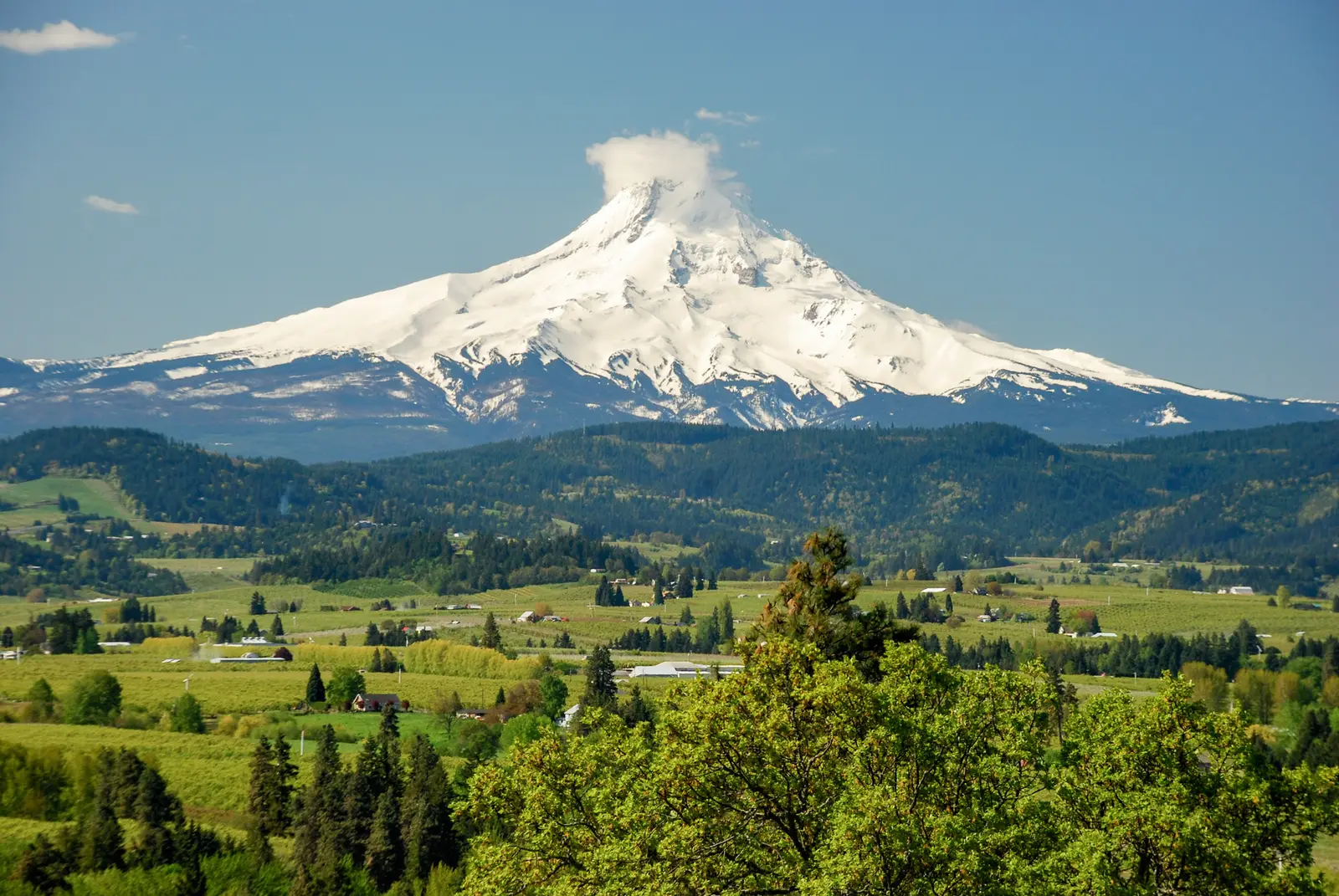
Photo: Gary Halvorson, Oregon State Archives, CC BY 4.0 A small county park on a knoll just south of town, about 400 feet above OR 35, looking straight down the Hood River Valley: rows of orchards, farms and forest, with Mount Hood filling the end of the view. It is the best look you get at the whole mountain, and it shows you where the afternoon's ride goes.
Tip: The park is signed from OR 35 just south of town, by way of Whiskey Creek Drive and Eastside Road. In April the orchards below are in blossom.
The roadmiles 107–138
US 26 down the mountain
US 26Two- and four-lane highway, long descentUS 26 runs past Government Camp, the village at about 3,850 feet where Timberline Highway turns off, then drops through the forest on Laurel Hill at up to about 7%, losing about 3,600 feet over 31 miles to Sandy. The road is two to four lanes wide and fast, with the villages of Rhododendron, Zigzag and Welches strung along the lower part. On summer Sunday afternoons the whole of Portland seems to be driving home on it: expect heavy traffic from Government Camp onward.
- 6mile 109.1
SightDetour
Timberline Lodge
Allow 1 hourAbout 5½ miles each way
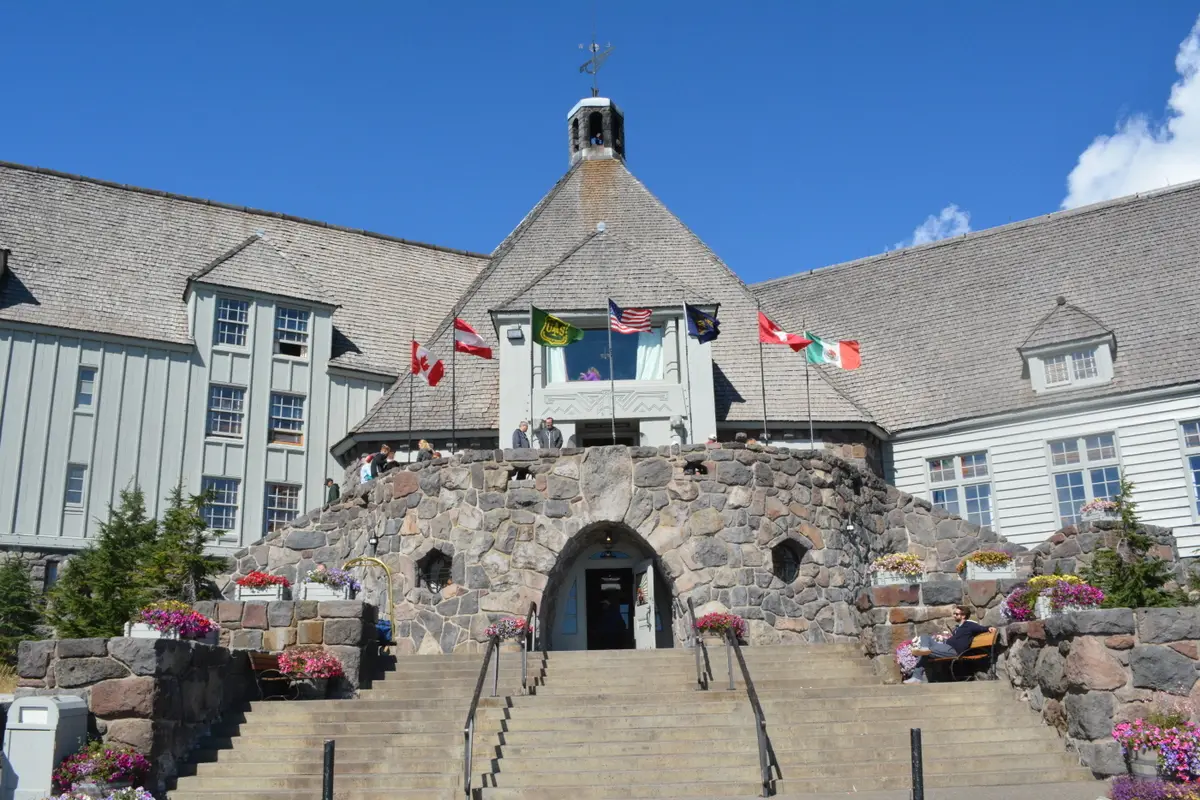
Photo: Jrozwado, CC BY-SA 4.0 A great stone-and-timber lodge at nearly 6,000 feet, built by Works Progress Administration crafts workers in the late 1930s and dedicated by Franklin Roosevelt in 1937. It is a National Historic Landmark, open to visitors, with hand-carved woodwork and ironwork inside, and its exterior stood in for the hotel in The Shining. Timberline Highway climbs about 2,000 feet from US 26 just east of Government Camp in a series of long, open bends, with the summit of Mount Hood ahead.
Tip: The side trip adds about 11 miles and 2,000 feet of climbing. It is often cold and windy at the lodge even in summer, so bring a layer.
The roadmiles 138–163
Sandy to Portland
US 26OR 99EMorrison BridgeFour-lane highway, then city boulevardTwenty-five miles back to the square. US 26 leaves Sandy across open farmland, then becomes Powell Boulevard through Gresham and east Portland, with traffic lights every few blocks. It is slow rather than difficult; fuel stations are everywhere. Grand Avenue and the Morrison Bridge take you back downtown.
- 7mile 163.4
Finish
Pioneer Courthouse Square
US 26 becomes Powell Boulevard through Gresham and east Portland, then Grand Avenue and the Morrison Bridge bring you back across the Willamette to the square where you started.
Before you ride
Licence and insurance
You need a motorcycle licence: in the US, a licence with a motorcycle endorsement. Visitors need a home licence that covers motorcycles, usually with an International Driving Permit; rental companies set their own rules on age, experience and insurance, so check before you book. Oregon requires liability insurance, and you should carry proof of it.
Rules of the road
Traffic drives on the right. Oregon's helmet law covers every rider and passenger, whatever their age. The loop is toll-free; the bridges across the Columbia to Washington at Cascade Locks and Hood River charge tolls, but the route does not cross them.
Fuel
There is no fuel on the route for about 50 miles between Troutdale and Hood River, and none for 37 miles between the last station on OR 35 south of Hood River and Government Camp, all uphill. Fill up near Troutdale and again in Hood River. Oregon allowed drivers to pump their own fuel only in 2023, and some stations still have an attendant at some pumps; you can use either. Pumps often ask for a US ZIP code, so with a foreign card pay inside first.
When to ride
June to September is the season, when the passes are dry and Timberline Highway is clear. Spring brings full waterfalls and blossom in the Hood River Valley in April, but snow lingers high on the mountain into late spring. From late autumn to spring, Bennett Pass, Barlow Pass and Government Camp see heavy snow; OR 35 and US 26 stay open but often require chains or traction tyres, and OR 35 can close in storms. Late summer can bring wildfire smoke, and fires have closed the old highway before. Check ODOT TripCheck before you go.
The waterfall corridor
On summer weekends the Historic Columbia River Highway between Bridal Veil and Ainsworth fills with cars looking for parking, and the waterfalls with walkers. A weekday or an early start makes all the difference. The timed-use permit rules for Multnomah Falls change from year to year; check Recreation.gov and the Forest Service's Columbia River Gorge pages before a trip between late May and early September.
Wildlife and safety
Watch for deer on OR 35 and US 26 at dawn and dusk. Mobile signal is patchy on the upper part of OR 35, so download the route before you leave. Up on the mountain it is often much cooler than in Portland, so pack a warm layer even in August.
Ride further
Liked riding this one on your own? Moto Mass lists small, local operators who run guided motorcycle tours in these countries.
Free ride routes