

West Thailand Kanchanaburi Experience
Kanchanaburi, Thailand
9 days
THB 89,000 / person

From the Bridge on the River Kwai to the cutting at Hellfire Pass, then home through the Khwae Noi valley past the wooden viaduct at Tham Krasae. A day on the history of the Burma Railway, on tarmac all the way.
In 1942 and 1943 the Japanese army forced Allied prisoners of war and far larger numbers of Asian labourers to build a railway from Thailand into Burma, through jungle and limestone hills, at terrible cost: more than 12,000 prisoners and tens of thousands of labourers died. Kanchanaburi sits at the Thai end of what became known as the Death Railway, and this ride follows the line west from the bridge over the river in town to the rock cutting at Hellfire Pass, then comes back by country roads along the Khwae Noi, past the timber viaduct at Tham Krasae where trains still run along the cliff above the river.
It is honest to call it mostly out-and-back. You ride Route 323, a wide divided highway, all the way out to Hellfire Pass and come back on it for about 35 km before turning off; only about 50 km, down through the Khwae Noi valley and the farming villages around Ban Kao, is new road, before the last 15 km into town on Route 323 again. The surface is tarmac throughout and the gradients are gentle, so a rented 125 cc scooter can do it, but it is a long day with fast trucks on the highway, and the reason to come is what you see when you get off the bike rather than the corners.
Longest stretch without a fuel station: about 57 km, between km 107 and km 164.
Start
Allow 30 min
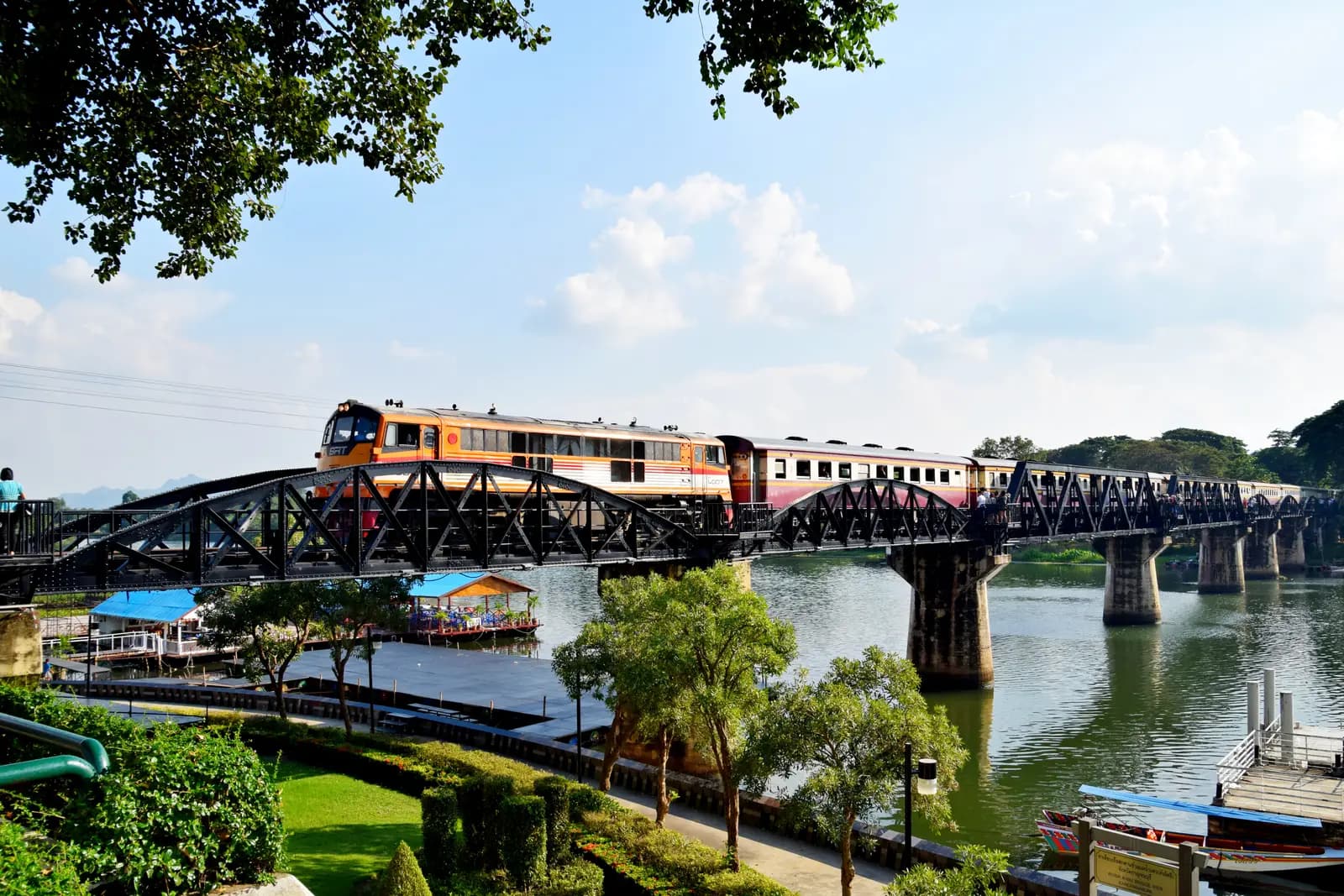
The steel railway bridge on the northern edge of Kanchanaburi was built with prisoner labour in 1943 and made famous by the 1957 film. The curved truss spans are original; the two straight spans in the middle replaced sections destroyed by Allied bombing in 1945. You can walk across it between trains, and the area around the station end has memorials and small museums.
Tip: Come early: by mid-morning the bridge is crowded and the day is already hot, and you have a long ride ahead.
The roadkm 0–15.3
A few town streets take you from the bridge onto Route 323, the main highway west towards Sai Yok and the Burmese border. It is wide, flat and busy, lined with shops and fuel stations. You ride this stretch again at the end of the day.
The roadkm 15.3–42.3
The town falls away and the highway runs through sugar cane and cassava fields, then climbs gradually onto a low ridge at close to 300 metres, the highest point of the ride. Long, open, sweeping curves; the traffic is fast, with buses and heavy trucks in both directions.
The roadkm 42.3–78.4
The road drops towards the Khwae Noi valley, passes Sai Yok Noi Waterfall right beside the carriageway, then climbs again through forested limestone hills to the Hellfire Pass Interpretive Centre. The centre is signposted from the highway; on a divided road you may have to ride on to the next U-turn gap and come back to reach the entrance.
Sight
Allow 45 min with lunch

A broad, low waterfall over limestone steps, right beside Route 323. You pass it on the way out, but it makes the better stop on the way back, when you will want shade, food and a cold drink: stalls and simple restaurants line the area around it. A Japanese-built C56 steam locomotive, of the class that worked the railway, stands on display a short walk away near the railway halt.
Tip: The falls are full in the rainy season and late in the year, and shrink to a trickle by the hot season, so judge your expectations by the month.
Sight
Allow 1½–2 hours
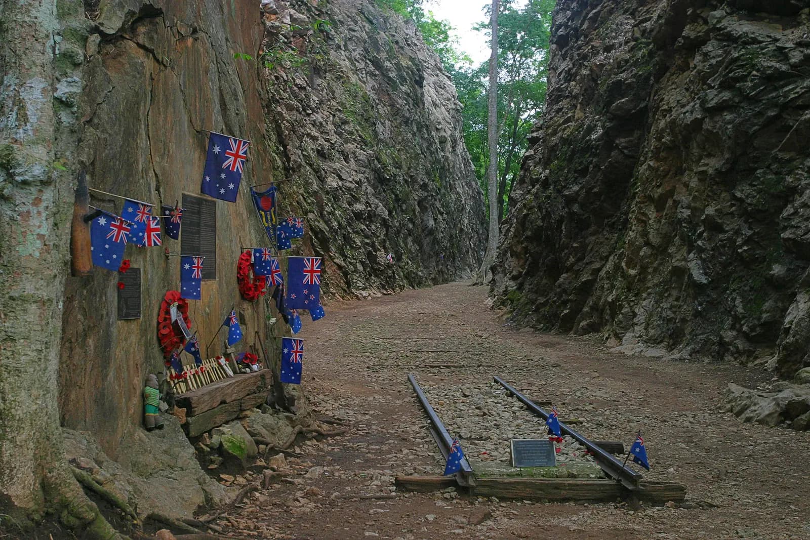
The Konyu Cutting, known to the men who dug it as Hellfire Pass, was cut through solid rock in 1943 by Allied prisoners and Asian labourers with hand tools and explosives, working through the night by firelight to meet Japanese deadlines. The interpretive centre beside the highway, built by the Australian government, tells their story, and a walking trail leads down steps to the cutting itself and on along the old railway bed. It is a quiet, moving place; visitors leave flags and wreaths at the rock face.
Tip: The steps down to the cutting are steep and the trail is hot; take water, and allow time to walk beyond the cutting, where the crowds thin out.
The roadkm 78.4–114.2
The same road back the way you came, with lunch at Sai Yok Noi. Watch your mirrors when you pull off and on: trucks come up fast behind you. Near the top of the ridge, leave the highway for Route 3343 towards Tham Krasae.
The roadkm 114.2–136.5
The best riding of the day. Route 3343 drops more than 200 metres in a few kilometres of curves to the river, then rural roads 4018 and 4032 wind between farms, villages and the railway to Tham Krasae and on along the valley. The roads are narrow, with dogs, cattle and farm vehicles, and tour traffic around the viaduct; take it slowly.
Sight
Allow 45 min
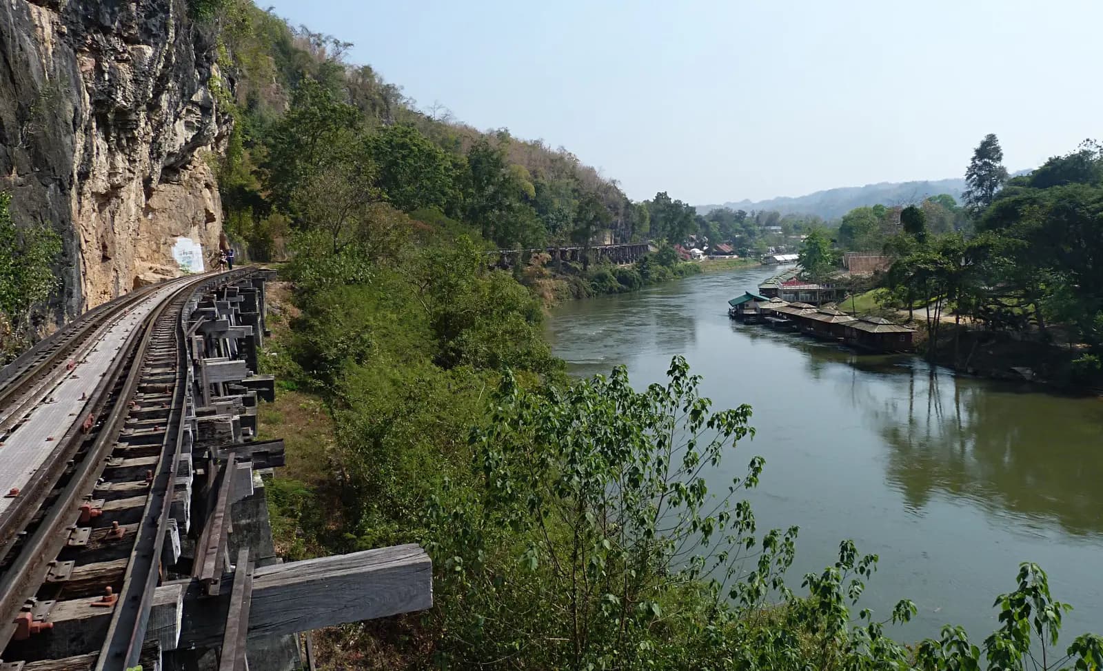
Here the railway clings to a limestone cliff above the Khwae Noi on a timber trestle, the Wang Pho viaduct, built by prisoners in 1943 and still in use by the trains between Kanchanaburi and Nam Tok. People walk along the line beside the river between trains, and a small cave shrine with a Buddha image opens off the track by the halt. The view down the river from the viaduct is one of the finest of the day.
Tip: Trains pass only a few times a day and cross slowly, but if you walk on the line keep to the side, listen for the horn and step well clear when one comes.
SightDetour
Allow 45 minAbout 1 km each way
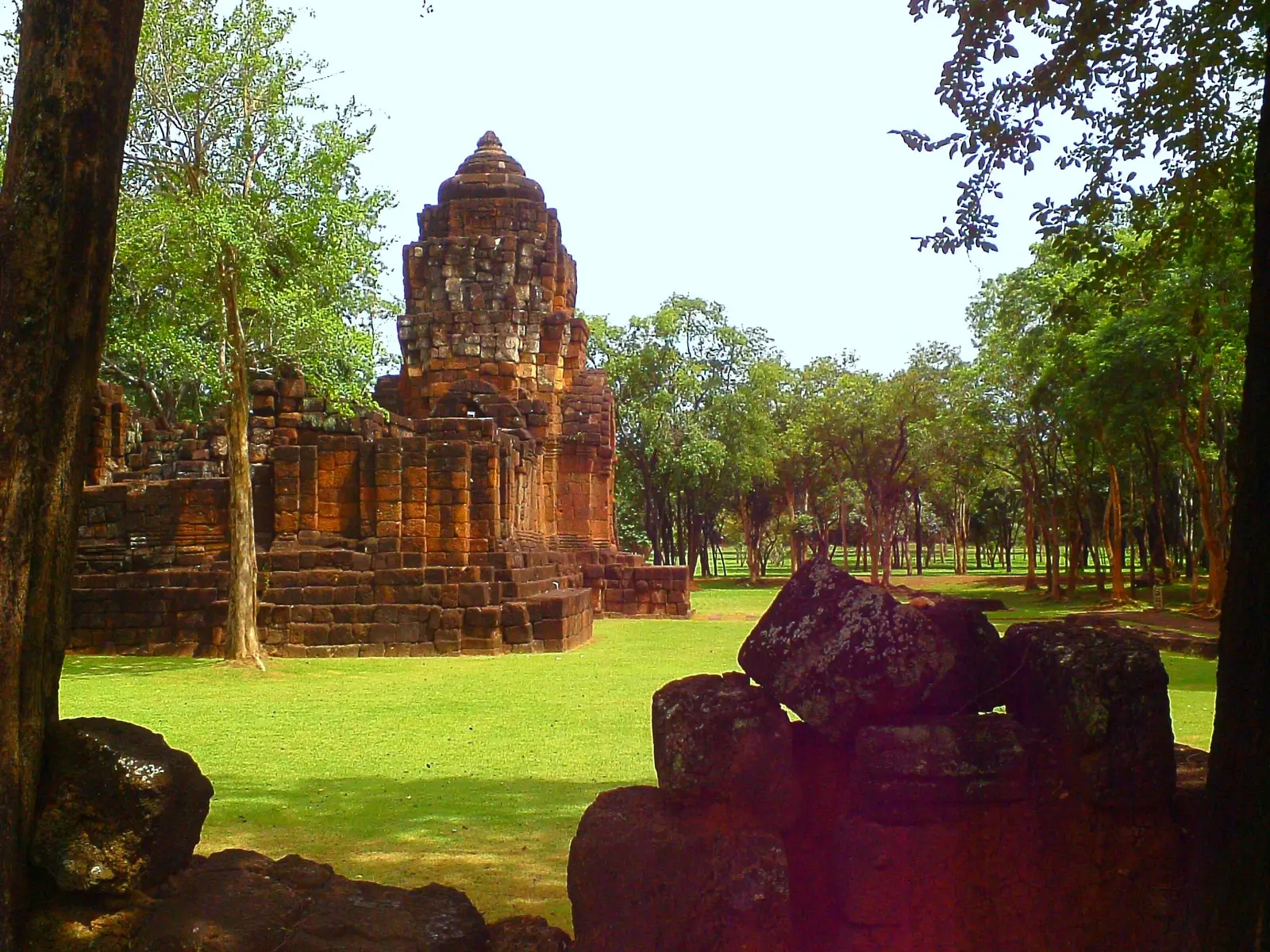
Long before the railway, this bend of the Khwae Noi was an outpost of the Khmer empire. The historical park preserves the laterite walls and sanctuary towers of a temple complex dating from around the 12th and 13th centuries, set in quiet lawns and shade trees. It is a calm, uncrowded contrast to the war sites.
Tip: An entrance fee is charged at the gate.
The roadkm 136.5–178.6
Route 3598 and Route 3455 run east past Prasat Mueang Sing and Ban Kao through flat farmland and villages, then Route 3305 and Route 3229 bring you back to Route 323, which you follow the last 15 km into town. Traffic builds as you near Kanchanaburi in the late afternoon.
Sight
Allow 30 min
A small museum on Route 3455 at the site of a prehistoric burial ground. Its story is tied to the railway: a Dutch prisoner who was an archaeologist, H. R. van Heekeren, found stone tools here while working on the line, and excavations after the war uncovered Neolithic graves, pottery and tools, now displayed here.
Tip: From here the roads through the villages to Route 323 are quiet and flat; it is an easy last hour back to town.
Finish
The loop rejoins Route 323 and brings you back to the bridge, where the late-afternoon light on the river is at its best. Kanchanaburi War Cemetery, where nearly 7,000 prisoners of war who died on the railway are buried, is a short ride away in the town centre and a fitting place to end the day.
Thailand requires a motorcycle licence: either a Thai licence or your home licence with an International Driving Permit that covers motorcycles. Police checkpoints on the main roads around Kanchanaburi do stop riders, and most travel insurance will not pay out if you ride without the right licence.
The gradients are gentle and the roads are paved, so a 125 cc scooter will make it. On Route 323, though, you share the road with trucks and buses moving much faster than a small scooter; a 150 cc scooter or a small motorcycle that can hold highway speed is more relaxed, especially two up.
There are plenty of stations along Route 323, both out and back. Once you turn off for Tham Krasae there is no fuel station on the route for over 50 km, through the Khwae Noi valley and Ban Kao, until you rejoin Route 323 near town. Fill up on the highway before the turn onto Route 3343.
November to February is the cool, dry season and by far the most comfortable. March to May is the hot season, and Kanchanaburi is one of the hottest parts of Thailand: start at dawn, carry water and finish early. The rainy season runs from May to October, with heavy afternoon storms; Sai Yok Noi Waterfall is at its best then, but the roads are slippery.
Thailand drives on the left. Helmets are compulsory for rider and passenger. Route 323 is a fast divided highway with heavy trucks: keep to the left lane, beware vehicles making U-turns from the gaps in the central reservation, and never ride the wrong way along the hard shoulder to reach a turning, however common it looks. Weekends and Thai holidays bring much more traffic to the sights.
Hellfire Pass and the war cemeteries are places of remembrance. Dress modestly, keep your voice down and be mindful with photographs. The Anzac Day dawn service on 25 April draws large crowds to Hellfire Pass.
These operators run guided tours from Kanchanaburi, listed alphabetically. Contact any of them through Moto Mass.
Free ride routes